Explore the transformative impact of photogrammetry on 3D modeling across diverse sectors. A technological breakthrough.
Photogrammetry, though it may sound complicated, is what is transforming 3D modeling across different industries. Architecture and gaming are among the areas that have changed through this technology that now give a very detailed as well as an accurate representation of the real world.
Photogrammetry analyzes 2D images to create accurate 3D models. Its new, cutting-edge technology has transformed 3D modeling in various industries.
It’s a technology that turns pictures into detailed and precise spatial representations.
Digital photogrammetry and 3D modeling are extremely versatile: they can be used as a solution in manufacturing, engineering, design, the entertainment industry, and healthcare.
The origin of photogrammetry dates back to the nineteenth century but thanks to digital technologies, this approach has found its way into the twenty-first century thus revolutionizing our understanding and reproduction of space around us.
In terms of realistic rendering and precision which are mostly out of reach for traditional methods, photogrammetry adds a sense of touch to 3D modeling. It has multiple applications that continue to proliferate.
It is not just another term for scientific jargon; rather it is a powerful technique that utilizes photographs to measure and map objects in three dimensions. This process has become a game by extracting exact information from photos.
Steps Of Photogrammetry
Triangulation And Basic Principles
The magic of photogrammetry is in triangulation, which is the process of finding the location of points in space by measuring angles between lines. This principle forms the basis for transforming photographs into three-dimensional wonders.
Image Acquisition
Photogrammetry begins with taking a series of high-resolution images from different viewpoints. This full data collection stage ensures a detailed and comprehensive representation of an object.
Processing Steps
In processing, advanced software identifies significant points in the pictures that it integrates into a point cloud. This cloud resembling a digital constellation serves as a base for creating complex 3D models.
How Does Photogrammetry Revolutionise 3d Modelling In Various Industries?
Photogrammetry has changed the way 3D modeling is done in various industries making it a revolutionary force in cutting-edge technology. This article will examine this process of transformation and its wide-ranging impact.
Architecture And Construction
In architecture and construction, Photogrammetry acts as a foundation for project planning. Architects can visualize their designs, identify problems, and streamline the building process through accurate 3D models derived from photographs.
One of the main advantages of photogrammetry is that it enables visualization and communication with clients to be enhanced.
Architects who make perfect 3D models are likely to provide vivid representations of their plans hence aiding customers’ comprehension about the planned spaces. This increases customer satisfaction while at the same time reducing misunderstandings throughout the construction phase.
Architects can quickly modify their plans when they have precise details from real-world situations without having to go to sites several times or undertake long measurement exercises.
This ensures time effectiveness, minimizes costs, and maintains precision in every aspect of the plan.
Photogrammetry is a technology that incorporates the real world into architectural design. By correctly portraying existing structures or natural environments, architects can integrate new concepts around their surroundings effortlessly.
This will ensure that new houses blend well with their environment and take advantage of distinct site features such as views or patterns of the sun.
Architects are adopting photogrammetry in increasing numbers due to its adaptability within various stages of design. It has advanced domestic architecture by enabling architects to make more accurate and detailed designs that are suitable for their clients’ needs.
Through this technology, architects can collect real-world data accurately and convert them into 3D models to get a glimpse of what the final product will look like.
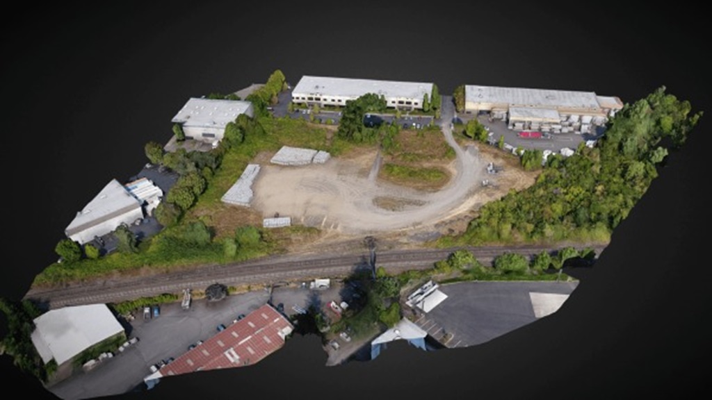
Geospatial Mapping And Environmental Studies
Photogrammetry provides geospatial mapping and environmental studies with an opportunity to create highly accurate and precise landscape models.
It helps monitor changes in the environment, research landforms, and plan sustainable development.
Generally, photogrammetric techniques are used along with well-calibrated aerial mapping cameras, other airborne sensors as well as satellite sensors.
The company also uses specialized mapping and processing equipment to produce mapping products such as digital elevation model data, vector feature mapping, topographic mapping, and ortho-rectified imagery.
The technique of photogrammetry has been used for a long time in combination with remote sensing in coastal erosion mapping which provides a lot of valuable data for environmental studies.
Topographic and base maps are widely accepted as tools for environmental studies and river change analysis.
Photogrammetry can generate terrain models that are highly detailed and accurate thus it is critical in geospatial analysis and mapping.
Monitoring environmental changes such as deforestation or urban growth becomes more efficient if one can use its comprehensive 3D models through its photogrammetry. It also helps in the production of accurate up-to-date maps which help to improve navigation and planning.
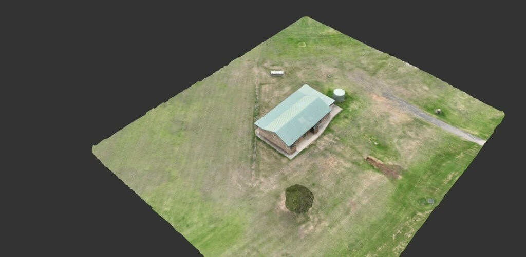
Real Estate
We live in a world where almost everything can be bought online. Everything is done online, from borrowing a book to renting or buying a house.
Nowadays instead of spending thousands of rupees on advertising some real estate agents have opted to employ modern drones. With the use of photogrammetry with a view of creating realistic representations about the places, they wish to sell or rent out.
Viewers or purchasers may examine the 3D representation of the house from all angles and get a good notion of its size which helps in decision-making.

Drone photogrammetry provides realtors with high-resolution, georeferenced aerial photographs that offer a comprehensive understanding of the property and its surroundings.
This is because 3D terrain visualizations help to understand topography, drainage, and prospective development issues.
It is possible to use this dense data set for 3D modeling and exact measurements of the property’s surface.
Similarly, the slope and elevation variances on any given property can be analyzed by lines connecting points of equal height.
These appealing photos highlighting properties at their best are one of how drone photogrammetry can revolutionize your real estate marketing strategies.
These aerial images, 3D models, and interactive maps can be put into websites, social media campaigns, and print materials without any difficulties thus allowing you to target a wider audience with more leads generated.
Entertainment And Gaming
Photogrammetry in the entertainment industry is used for making highly realistic characters, environments, and assets which play an important role in immersive gaming experiences.
Furthermore, many video game developers utilize this measurements-from-photos technique to come up with various 3D models that are subsequently utilized as in-game assets.
These could range from small portable items such as bottles or weapons to large-scale settings like cityscapes or mountains.
Using photogrammetry in video games, there is no limit to the things that can be captured, game developers can model, edit, and put in.
Furthermore, with the advancement of game realism, more film-like production techniques are being used in game design such as pre-visualization (pre-viz). Photogrammetry (using a camera to measure and model) has a strong ability to help in pre-viz.
For example, Modern Warfare developers used photogrammetry tools to take photos of a car.
Engineers took three days to capture 10,000 photographs of the vehicle. The program then produced one car made up of 50 million polygons.
Finally, all that remained was removing shadows from the model. This would help in making some slight adjustments; after which it would be ready for inclusion into levels for the game.
Photogrammetry is how high-quality realism will be achieved in these games in the future saving creators time, and money and providing gamers with believable gameplay.
The Essence of Photogrammetry in 3D Modeling
The significance of photogrammetry in 3D modeling is that it enables the conversion of image-derived raw data into visible and tangible 3D models.
By taking photographs from different perspectives, photogrammetry can create highly accurate 3D models of almost anything, ranging from vast landscapes to small objects.
Defining Precision
With an unmatched ability to capture fine details, photogrammetry takes precision to another level in 3D modeling. This means that such models closely resemble actual things.
Cost-Effective Solutions
Traditional methods of 3D modeling often require expensive equipment and extensive labor. On the other hand, Photogrammetry uses cameras which are everywhere; reducing costs without sacrificing quality.
Why Choose Upload Media Services For Photogrammetry And 3D Model Photography In Australia?
Upload Media Services has been serving the media industry for more than fifteen years. We have a team that is committed to taking your ideas from concept to a 3D model reality. Therefore, we have experienced professionals and resources required to cater to all your photogrammetry and 3D Model photogrammetry needs. Moreover, we are:
- Certified and licensed by CASA
- Public Liability Insurance of $12 Million
- Professional Liability Insurance of $6 Million
- Safety assessments for jobs
- Mine/Construction Spec Vehicles and Full PPE
- Drone fleet of the future
- GNSS ground control with PPK precision
How Can Upload Media Services Help You with Photogrammetry and 3D Model Photography In Australia?
If you want to have your 3D model photography and photogrammetry outsourced in Australia, choose Upload Media Services. We will help you make choices as well as help you interpret the results. We use a comprehensive approach and innovative methods, and we know our local market and work with others in the field.
Our company works closely with our clients so that they can fully understand their specific requirements; we also personalize our services so that each project will be a success. Call us today and let’s change your idea into an eternal masterpiece!
FAQS Regarding Photogrammetry And 3D Model Photography
What Is The Difference Between Photogrammetry And 3D Modelling?
Photogrammetry is the process of creating 3D models from photographs whereas 3D modeling is the process of creating 3D models using geometric primitives like points, lines, and surfaces.
What Are Two Benefits Of Photogrammetry?
The 2 pros of photogrammetry are:
- Non-contact, no wear and tear
- High level of precision and accuracy, even on large objects.
Can I Create A 3D Model From Photos?
Yes, you can. Photogrammetry would be one of the best ways to do it.
What Are The Cons Of Photogrammetry?
The disadvantages are:
- Relies on good lighting conditions
- Less accurate