Uncover how drones revolutionize the construction industry. From precise surveys to real-time monitoring, witness the future of construction.
Originally used for military purposes and hobbyist photography, drones have quickly spread to various industries and the construction sector is leading this trend.
These unmanned aerial vehicles (UAVs) are useful in increasing the efficiency of operations in different parts of a building.
Traditional surveying and inspecting of construction sites took so much time, effort, and resources. Contrastingly, drones have revolutionized these processes by giving aerial views for accurate measurements and data capture.
This technology is being embraced by construction firms worldwide to increase output, improve safety standards, and reduce costs.
Drones have changed the world of construction but they are also important tools that have been used to enhance safety, improve efficiency, and benefit from projects.
In this article, we will be looking at how drones are used in the construction industry as well as how they could be applied for agile growth in construction.
Advantages Of Drones In Construction Industry
However, it is important to know what advantages using drones on site would bring to enable effective development of the site before understanding what drones mean to the construction industry.
Cost-Efficiency
Drones have been hailed as marvels of technology and bring about a transformative wave in the construction industry, particularly by modifying operational costs.
A streamlined process enabled by drones is one of the main contributors to cost-effectiveness. These unmanned aircraft use highly modernized systems that can capture data precisely and efficiently.
Previously, a lot of labor was required at construction sites for various activities such as surveying, inspection, and transportation of materials.
Tasks that were done through human intervention before can now be conducted autonomously using drones that have been introduced in the construction industry.
This reduces the cost of labor and ensures safety by limiting workers’ exposure to hazardous conditions in construction sites generally.
Enhanced Safety Measures
Integration of these crafts into the building industry has resulted in a new level of safety, fundamentally changing the old landscape where employees constantly find themselves involved in dangerous tasks.
One of the primary methods by which drones improve safety is their ability to carry out aerial surveys and inspections.
To traditionally evaluate construction sites, workers used to climb scaffolding or tread on fragile surfaces, exposing themselves to possible falls and other accidents.
Nonetheless, drones make these hazardous jobs possible from afar. Drones feature high-resolution cameras and sensors that can take vivid photos and collect data from various angles thereby giving detailed information about the construction site without endangering human beings’ lives.
Their exclusion of hazardous duties for workers significantly adds to the overall safety at construction sites.
Improved Decision-Making
Such real-time information collected by drones helps in making better decisions by project managers, optimizing project schedules and resource allocation.
Optimizing resource allocation is another vital part where real-time drone data proves its worth
Drones with advanced sensors and cameras capture detailed pictures and data about the construction site which include the status of resources such as materials and equipment.
The same also gives a bird’s eye view of the whole building area which allows quick examination before making any necessary actions by project managers. Moreover, they provide an overall view of the site where buildings are taking place.
This could be exemplified by the fact that if there is an unanticipated delay in a certain area, project managers can move resources or change the project schedule immediately to reduce its impact on the whole timeline.
Drones Revolutionize The Construction Industry
It would mean a complete revolution for your company’s entire operations regarding tendering, planning, and the phase of construction if you incorporated drones in your workflow. The following are some of the factors that have changed everything about the construction business using drones:
Planning And Scheduling
Before excavation, it is imperative to conduct a thorough site analysis. In-depth site evaluation is the beginning step of smart project planning involving a holistic view of the building location with some key items like topography, soil content, and environmental effects.
At this stage, drones equipped with high-quality sensors come in handy as they provide comprehensive field data necessary for developing and implementing a comprehensive project plan.

At present, it becomes easy to understand why drones are useful in buildings. Drone visual data helps to understand what the terrain looks like on a large scale: slope, elevation, water flow patterns through drains, and any other vegetation types. Such images can be used to easily pass messages to employees or customers.
To decide whether the location meets the project’s logistical requirements, this data can be reviewed by the stakeholders. They can find out any access limitations to the site or other issues that can affect material and equipment transfer as well as construction activities.
Thus, gives a bird’s eye view that enables project managers and planners to accurately evaluate the landscape, topography, and existing structures.
With this information, they help in developing complex three-dimensional models of construction sites. Architects and engineers will use such models in design validation so that they have structures that are compatible with the terrain and environmental factors around the area.
Surveying And Mapping
Drones equipped with high-resolution cameras and LiDAR technology provide accurate survey data, aiding in precise project planning.
When planning complicated, large-scale building projects, it is critical to use topographic maps. They can expose expensive flaws in designs that are not suited to certain terrains.
It is important to note that even though topographic maps are useful, they incur high costs and require one to spend a lot of time making them. Consequently, maps do not always get updated at the beginning of a project.
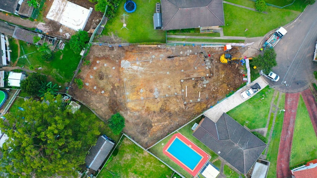
This involves creating precise maps and models of construction sites using aerial photography together with photogrammetry techniques.
Drone-captured high-resolution aerial footage effectively covers enormous regions, offering a visual depiction of the site’s attributes.
Photogrammetry algorithms process overlapping photos to create 2D and 3D maps including topographic ones that show elevations, contours, slopes, and other topographic features.
Orthomosaic maps are made by stitching several photos together giving geometrically accurate and orthorectified images of the place allowing for precise measurements, distance calculations, and visual analysis.
With drones, designers can include existing structures, utilities, and vegetation in their design processes; hence assisting in asset inventory.
In general, using drones for surveying and mapping has many advantages such as fast data gathering, high precision level, fully visualized information, and improved decision-making skills.
The integration of surveying and mapping with drones gives significant insights into design, engineering, and asset management processes which enhances construction project efficiency and quality in the end.
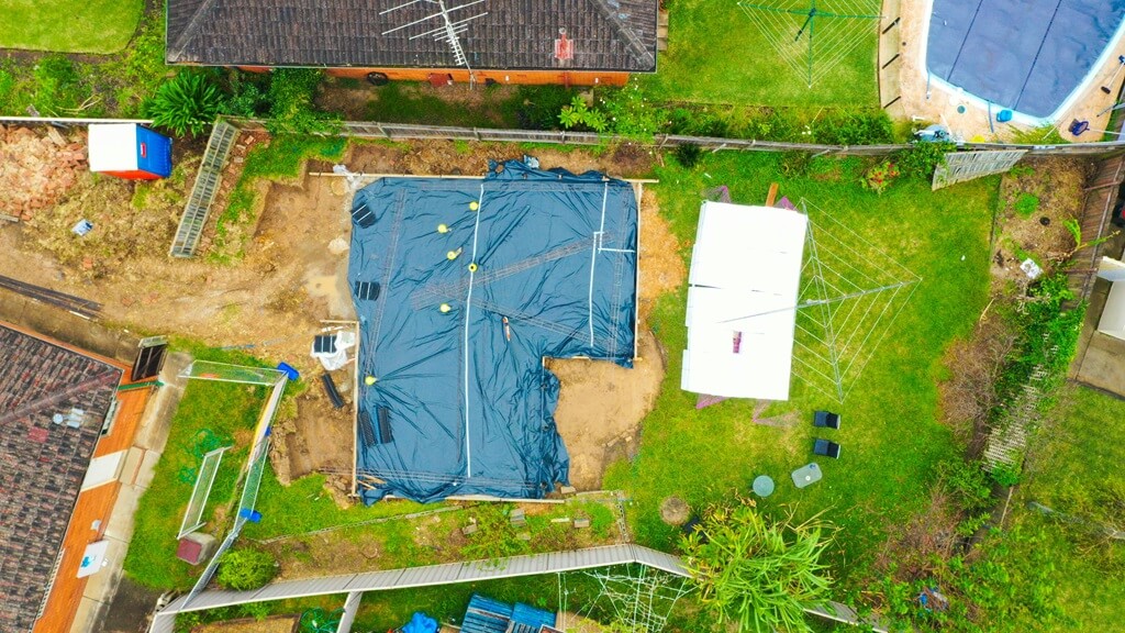
Monitoring And Inspections
Drones play an important role in quality control since they capture high-resolution pictures as well as data that allows extensive inspections or even problem identification.
During ground inspections, inspectors can employ complete imaging to find invisible faults such as cracks, corrosion, or surface problems at the microscopic level.
Inspectors can quickly note any deviations or faults from the construction process by comparing this data with construction blueprints or 3D models.
This early notice of defects enables quick rectifications that ensure the project meets quality standards.

In addition, drones make it easier to systematically document and monitor reported problems hence providing clear records of issues that need to be addressed.
On top of this, drones provide a fast and accurate method for tracking the progress of construction throughout the life cycle of projects.
Again, drones aid project managers in checking how different construction jobs are progressing by frequently taking aerial pictures or carrying out photogrammetric surveys.
Additionally, these drones allow for good communication within the team that is constructing hence allowing all stakeholders to witness and understand how well the project is advancing.
Coordinating this visual documentation of development progress on the ground reduces misunderstandings among stakeholders and creates a shared understanding among them about what stage in development the project is at.
Why Choose Upload Drones for Your Construction And Development Endeavors?
Make your construction industry work smoother through our comprehensive drone services. Harmonize your construction work through our expansive drone services
To achieve all your building and construction goals safer, faster, and with precision, don’t hesitate to consult Upload Drone Services.
Our highly trained and dedicated professionals use different technologies and techniques to provide site surveys, progress monitoring, inspections, and marketing materials.
From construction progress/reports to live site monitoring, we’ve everything covered to help you save time and money, improve safety, and ensure the quality of your construction project.
Trust Upload Drone Services to be your aerial partners, we provide a dynamic view of your construction site like never before. Consult with us today and let’s elevate your projects to new heights.
How Can Drone Upload Media Services Help In Construction Endeavors
We are a team of experienced drone operators with the necessary equipment and permits to complete your project. You may also want to compare our rates against other commercial providers to make an informed choice regarding which one would best suit both your budgetary allocation as well as specific requirements you might have.
Get ready to soar above the ordinary. Call us anytime for consultation purposes that will change the way you view real estate development from now on. Working jointly we will redefine the skyline as well as establish an epitome that stands long after people are gone.
Precision in Detail
Our drones come with highly developed technology, enabling us to capture all the tiny details about your construction project. From start to finish, we provide clear pictures for you to watch the progress of your building as clearly as possible.
Seamless Integration
Our services are aimed at being part and parcel of your project. Working closely with your team, we seek to understand what you have in mind so that the final product is consistent with your vision.
Enhanced Decision-making
Using our high-resolution aerial photos and videos, you will always have a rare perspective that can help you make decisions rapidly.
FAQS For Construction
Can Drones Be Used For Construction?
Yes, drones are a much faster and safer alternative than traditional land-based surveying methods in construction projects.
How Much Do Drones Cost To Use In Construction?
It depends on the type of drone, the services being provided, and the size and complexity of the project. However mid-level drones used on small sites can cost less than 2000$ while serious mapping equipment might range from 10000$-100,000$. Contact us to know our prices.
What Is The Advantage Of Drones In Construction?
Pros of drones in construction are:
- Ensure safety
- Inspect the entire site
- Monitor in real-time
- Enhance construction site communication
What Is The Future Of Drones In Construction?
The future looks promising as more and more companies, and industries are adopting to take advantage of this technology.