Explore the revolution of aerial mapping surveys across industries! From construction planning to agriculture resource management, discover how surveying and mapping are reshaping our world.
Aerial mapping surveys, employing technologies like drones and crewed aerial vehicles, have emerged as transformative tools across various industries.
Surveys involve the use of aircraft or unmanned aerial vehicles (UAVs), commonly known as drones, equipped with cameras, LiDAR (Light Detection and Ranging), or other remote sensing technologies to capture high-resolution images and data of the Earth’s surface.
Aerial Mapping surveys have been among the most popular forms of surveying for many different types of industries and have gained huge favor among individuals.
These surveys have revolutionized various industries by providing accurate and up-to-date geospatial information. This information is used by professionals to identify a problem in the asset. It provides unrivaled geospatial insights, allowing for exact mapping and analysis.
Despite the development of drones and satellites, crewed aerial surveying is still useful for a variety of purposes. The primary components of aerial mapping surveys include:
Data Capture: Aerial mapping surveys acquire high-resolution photographs using specialized cameras and sensors, which are commonly in the form of orthophotos (georeferenced aerial images) and point clouds (a collection of data points representing an object’s exterior surface).
Data Processing: The recorded data is meticulously processed using specialist software to correct distortions, improve accuracy, and generate smooth and accurate maps.
Analysis and Interpretation: Aerial mapping surveys yield a plethora of data that may be studied to yield significant insights. This covers topographical analysis, categorization of land cover, vegetation health evaluations, and much more.
Aerial Mapping Surveys Impact In Different Industries
Drone surveying provides advantages such as increased accuracy and efficiency. They have become an important factor for many industries.
Aerial photographs have a significant impact on the precision of drone survey mapping, making it a valuable tool for a variety of sectors. Drone surveys have been revolutionizing many industries, some of them are given below:
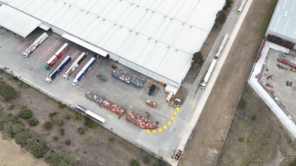
Construction And Engineering Industries
Drones allow you to monitor the progress of a construction site using a technique known as “construction aerial progress monitoring.”
This entails frequently scheduled drone flights to collect project data workflows and document progress and revisions, ensuring that the scope stays as agreed.
The most apparent and widespread application of drone surveying for construction enterprises is site surveying.
Drone-based surveying enhances the speed and convenience of conducting site analysis, making it feasible to perform more frequent assessments in the initial phase of any construction earthworks project. This ensures the availability of up-to-date data.
Aerial Mapping Surveys combined with a full-featured surveying program like Propeller enables project teams to use 3D site photography to compare plans and as-built documentation to finished work.
Construction businesses can leverage drone surveying skills to track smaller, specific assets as well. Drones are capable of conducting inventory evaluations with a higher degree of detail, leading to time and cost savings.
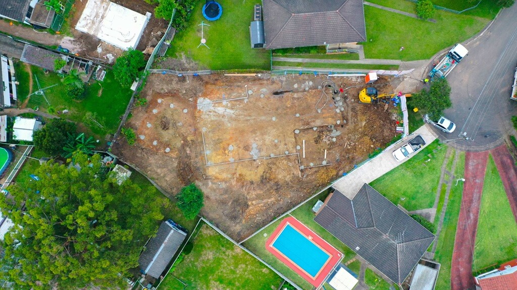
Real Estate Industries
Real estate property surveys are an integral aspect of every real estate transaction’s due diligence procedure. The survey’s accuracy can be the difference between a successful sale and an expensive disagreement.
Drones have been a major changer in the real estate property survey market in recent years.
Surveys and mapping capture incredibly detailed aerial images and video of property borders and areas which would help to know more about the property.
Aerial Mapping Surveys can even identify concealed features like subterranean water pipes, septic tanks, and electrical cables which would help in effective management.
Finally, drone mapping and surveys have emerged as a significant instrument in the real estate sector. They may be used to improve security and safety by providing monitoring, surveillance, and security.
Suverys will become increasingly vital in guaranteeing the safety and security of the real estate business as technology advances.
Drones surveys will continue to play an increasingly crucial role in the real estate sector over the next decade. As technology progresses, agents will be able to employ drones in more efficient and cost-effective ways to do business.
Drones are predicted to become increasingly widespread in real estate, where they will be utilized for a range of functions ranging from marketing and inspections to mapping and monitoring.
Agriculture Industries
Precision agriculture, enabled by insights gained from aerial mapping surveys, has ushered in a new era of farming efficiency and sustainability.
The incorporation of new agricultural technology, such as drones outfitted with high-resolution cameras and sensors, has supplied farmers with a plethora of data that can be used to make educated decisions throughout the crop production cycle.
Aerial mapping surveys provide farmers with a bird’s-eye perspective of their fields, allowing them to analyze crop health in unparalleled detail.
Farmers may recognize minor differences in plant health, detect early symptoms of illness, and locate regions with nutritional deficits by using multispectral and thermal imaging.
Water management is an important component of agriculture, and aerial mapping studies help to optimize irrigation operations.
Farmers may monitor soil moisture levels and spot regions that are under or over-irrigated by taking comprehensive photographs of the fields.
The capacity to make data-driven decisions, owing to aerial mapping surveys, directly leads to higher agricultural output.
Farmers may use real-time data to deploy precision farming techniques, optimize planting patterns, and fine-tune cultivation operations.
Insurance And Risk Assessment Industries
The integration of aerial mapping surveys is transforming the insurance and risk assessment sectors.
Drone mapping is a safer inspection approach that decreases the danger of work-related human accidents and the risk of causing damage to the client’s property while completing the operation.
Insurers may analyze numerous risk variables, such as proximity to natural hazards, property conditions, and the surrounding environment, by evaluating high-resolution photographs and 3D models of properties.
Fraud accounts for around 10% of property and casualty insurance losses and loss adjustment charges each year, according to the Insurance Information Institute. This number corresponds to $32 billion in property-casualty fraud each year.
Utilizing drone data can enhance claims management by inspecting the original state of a property and its condition following a reported event. This provides indisputable proof, thereby lowering the chance of fraud.
Insurance firms will be able to set rates more correctly by analyzing risks better than ever before, thus enhancing consumer happiness.
Drone data might be used to check the presence of elements that make houses less dangerous to insure, such as storm windows or a neighborhood gate.
Telecommunications Industries
Drones, satellites, and advanced geospatial technologies are making aerial mapping possible, which is transforming how telecommunications companies plan, construct, and run their infrastructure.
Telecommunications is currently one of the fastest-growing industries. Drone surveying and mapping have tremendously benefited this business by simplifying and optimizing its operating operations.
Companies can analyze terrain, find suitable places for cell towers and antennas, and create the most effective network expansion architecture by acquiring high-resolution photos and 3D models of landscapes.
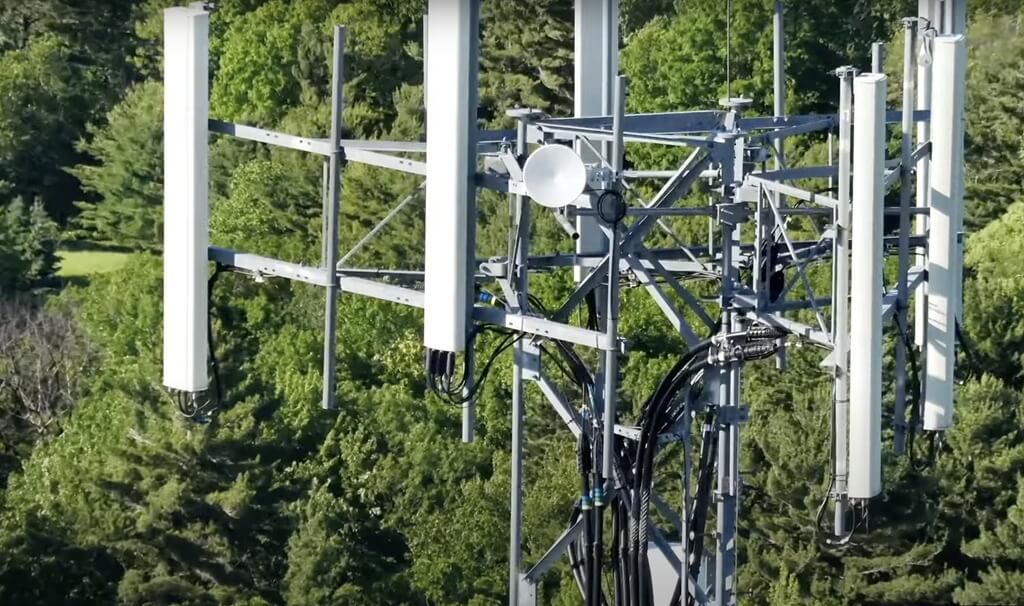
Aerial mapping surveys provide precise and up-to-date geographical information, which simplifies network implementation and growth. Aerial mapping surveys aid in the investigation of signal propagation.
Telecommunications engineers can anticipate signal strength and identify possible barriers that may impair network performance by taking into account elements such as geography, vegetation, and urban buildings.
Aerial mapping surveys are critical for continuing maintenance and monitoring of telecommunications infrastructure.
Drones with high-resolution cameras examine towers, antennas, and other components for corrosion, damage, or system faults.
Natural Resource Management
Drones provide large-scale, thorough surveys for natural resource management, yielding precise, high-resolution maps, models, and telemetry data.
According to studies, 38% of forestry workers presently rely on drones for data collecting and decision-making
Drones equipped with high-resolution vision sensors and multispectral sensors can assist in mapping forests, sampling vegetation, and monitoring and managing the health of forests and animals.
Surveys can aid in the collection and processing of data related to the health of trees, plants, and bushlands.
Thermal photography, topography surveying, and aerial mapping assist horticulturists and forest officials in locating unhealthy plants and directing them toward bettering their circumstances.
After collecting aerial footage, professionals with advanced software modeling skills may utilize them to remove trees, thereby constructing bare-earth landscape models.
This activity contributes to future infrastructure development by allowing operators to examine acreages of remote forestry land from a single viewpoint, decreasing the requirement for labor and time-consuming traditional approaches.
Aerial mapping surveys can be used to research and monitor animal populations. They let researchers follow animal migrations, determine species distribution, and measure ecosystem health. This data is critical for conservation efforts.
Why Choose Upload Media Services For Aerial Mapping Surveys In Australia?
Upload is a full-service content creation agency in Sydney. Our team of experienced marketers, photographers, and video producers utilize advanced video production and commercial photography techniques to bring your communication vision to life.
We create customized, impactful content that resonates with your target audience. We take the time to understand your customers and ensure that their content speaks directly to them.
We uphold our commitment to delivering high-quality service through our investment in advanced drone systems and camera equipment.
How Can Upload Media Services Help You In Aerial Mapping Surveys In Australia?
Businesses, organizations, and individuals utilize our services to capture stunning aerial images and videos for various purposes, including marketing and advertising, real estate, construction, agriculture, industries, and emergency or rescue situations.
We are committed to providing our clients with the highest quality aerial media production services.
Our team of experienced pilots and photographers are CASA certified and have years of experience in the industry. We use state-of-the-art equipment to ensure that our clients receive the best possible results. Some of our expertise are:
Aerial Mapping Expertise
We specialize in aerial mapping, providing expertise in capturing high-quality imagery and data for mapping purposes.
Drone 3D Modeling
We offer drone 3D modeling services, leveraging advanced technology to create accurate and detailed models from aerial perspectives, enhancing the precision of mapping
Drone Land Survey
With drone technology, we conduct efficient and precise land surveys, contributing to comprehensive mapping efforts for various applications
Editing Services
We edit and refine captured aerial data, ensuring optimization for mapping purposes and enhancing the overall quality of survey results.
We use powerful analytics to the data to answer local, site-specific queries. Our excellent analytical capabilities encompass Artificial Intelligence and Machine Learning, Computer Vision, and thermal imaging, to mention a few.
FAQS On Aerial Mapping Surveys
Is Aerial Mapping The Same As Surveying?
No, aerial mapping and surveying are related but distinct processes. Aerial mapping focuses on creating maps and visual representations from the air, while surveying encompasses various methods, including both aerial and ground-based techniques, for measuring and mapping the Earth’s surface.
What Tools Are Used In Aerial Mapping Surveys?
Tools used in aerial surveys include drones, airplanes, satellites, LiDAR, and specialized cameras. These tools capture high-resolution imagery and data for mapping, monitoring, and analyzing landscapes from the air.
Why Is An Aerial Mapping Survey Important?
An aerial mapping survey is important because it provides accurate, high-resolution data for monitoring and analyzing landscapes, aiding in environmental management, resource exploration, disaster response, and infrastructure planning.
What Is The Purpose Of A Mapping Survey?
The purpose of a mapping survey is to accurately measure and represent geographic features, providing essential data for navigation, land development, resource management, and various planning purposes.
Why Are Aerial Surveys Done?
Conducting aerial surveys enables the gathering of high-resolution data from the air, facilitating accurate mapping, monitoring, and analysis of landscapes. This approach is essential for various purposes, such as environmental management, resource exploration, and infrastructure planning.
By employing advanced technologies, including remote sensing devices and drones, surveyors can efficiently capture detailed information over large areas. As a result, this method facilitates informed decision-making and supports a wide range of applications in diverse fields.