Discover the innovative ways to utilize drones for tracking progress on new developments and subdivisions. Learn how this technology revolutionizes the construction industry.
Imagine your position as a magic watchtower from which you can see how new projects and subdivisions are coming into existence.
Among such technological advancements, drone technology has become more common. The adoption of drones for monitoring construction during their life cycle has revolutionized project management, giving numerous advantages and an edge over other construction firms.
Monitoring and managing construction projects have always been complex and strenuous. As a result of the technological improvements, the construction industry has seen significant changes aimed at increasing efficiency and reducing costs.
Drones have actualized this dream by providing an interesting aerial view that not only arouses curiosity but also acts as a powerful development measurement tool. By integrating drone technology into building projects, project managers can enjoy several benefits.
Some of the benefits that come with using drones include accurate surveying, improved safety measures, efficient progress monitoring, and significant cost savings.
As the construction industry develops, new technologies like drones are becoming essential for competitive advantage and successful completion of projects.
Uses Drones To Track Progress On New Developments And Subdivisions
Often associated with entertainment flight, drones have become essential for various sectors. But how did these flying gadgets become part of the tracking game? We will now look at how drone technology began and its disruptive potential.
Cost-Effective Insights In New Developments And Subdivisions
Drones used in monitoring the building lifecycle can result in huge savings on costs and time on new development and subdivisions.
Traditional methods of data collection and monitoring require human labor; thus, it is both expensive and time-consuming.
On the other hand, drones can collect immense volumes of data very quickly compared to what would take days, weeks, or even months when done manually hence reducing the need for much manual labour.
Again, drone aerial views can help in uncovering damages at early stages leading to the resolution of issues on a timely basis thereby reducing chances of expensive rework or project delays.
Through cameras and sensors, drones placed on construction sites can monitor them in real-time.
This not only improves project management by measuring progress but also helps identify possible challenges that may hinder development at an early stage. Some problems could suddenly emerge in the complex world of new developments.
These modern drones have sensors that enable the detection of things like soil erosion, and water logging in addition to structural-related issues thereby enabling their correction by developers.
Mapping the Unseen: Aerial Surveying and Mapping
When it comes to construction projects, getting accurate surveying and mapping data is one of the most difficult issues. Often, traditional methods involve manual measuring and collecting data that can take a long time and lead to mistakes.
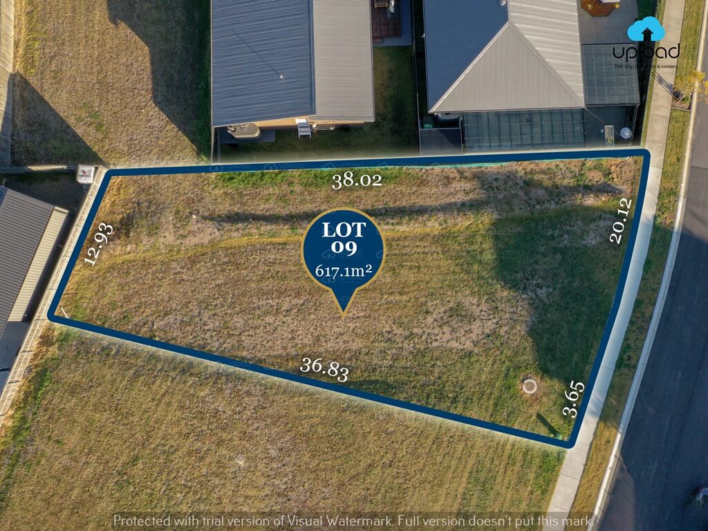
Some drones are equipped with high-resolution cameras and mapping software which allow them to record very precise aerial photos of the construction sites. This makes it possible for them to create topographic maps, 3D models, and orthomosaic images that have precision.
If there is real-time data access then everything changes for the developers’ decision-making process. Immediate drone feedback enables project supervisors to make informed judgments promptly thus avoiding delays and expensive mistakes.
This information can be used for precise measurements, volume calculations, and site investigation thus saving time as well as money.
Moreover, drones can do more tasks in a short period. They collect aerial imagery within minutes over vast areas which is crucial given the size of residential housing expansions
Besides, CM-level accuracy could be achieved by a drone land survey. In less time, drones can provide better land surveys than any other way.
Real-Time Updates: Photo Documentation And Data
Additionally, they can do photo documentation which is one more benefit of using drones in new developments. The quality of workmanship or how quickly it was done may be shown through them so that the general contractor
Swift deployment and flight are possible with drones. In minutes, you can launch a drone with a few fully charged batteries, a responsible operator on the controls, and favorable weather, which can then fly across the whole work site within a short period while taking images.
Drones’ small size makes them more agile. They can therefore go to places that were unreachable before, and provide unusual points of view whilst sending video in real-time or uploading it to the cloud for later use.
Never before have construction project managers had so much visual data at their fingertips. For instance, if you hire many subcontractors to install asphalt roof shingles over the development, then fast drone flights could be done right away.
This shows where houses have been finished and whether the project was carried out as per your construction requirements.
Photo documentation is also necessary in addressing any issues that might arise later on. When there are design flaws, poor management, or arguments about project scope, aerial images provide a physical record to turn to.
The future of construction photo documenting belongs to drones without question. Nothing else comes close in terms of value packed into such minuscule packaging.
Beyond Borders: Earthwork Reporting
Soil work status can be kept track of with regular earthwork data from drones. This way you may plan and tell all team members if the project is behind or ahead of schedule.
An earthwork survey involves collecting site data for earthworks to plan, estimate, locate and lay out various building phases. It includes identifying crucial reference points that can be used to control and oversee construction progress.
Drones are so fast that they produce cut-fill reports regularly. You will always know exactly what soil you’re moving at any given time in addition to who should account for it.
Additionally, real-time feedback using drones is possible for all team members.
Stakeholders can also identify small issues early enough through regular cut-fill reports. In addition, keeping current digital images of the worksite is cost-effective.
On the economic front, drones will help you reduce unexpected expenditures. Traditional earthwork surveys typically result in expensive change orders, but when drones are used this potential margin for error can be greatly reduced.
Time is money in construction earthwork, as it is in all businesses. As a result, you must ensure that your initiatives are finished on time or ahead of schedule.
Drones enable you to take command of project schedules through improved documentation and grade management.
Enhanced Safety: Risk Mitigation On New Developments And Subdivisions
New Developments And Subdivision sites contain multiple safety dangers, and it is critical to implement procedures that assure worker safety and reduce possible hazards.
Drones have shown to be a vital tool in limiting risks and maximizing outcomes, from finding unbuildable locations to settling contractor disputes.
Their capacity to offer exact data, improve stakeholder communication, and simplify many facets of the development process heralds a new era of efficiency and sustainability.
Drones outfitted with cameras and sensors can be used to monitor building sites in real time, detecting safety issues such as illegal individuals, unstable structures, or dangerous items.
This proactive strategy allows project managers to take quick action to strengthen safety measures, lowering the likelihood of accidents and improving overall site security.
Throughout the building period, drones provide a dynamic way of compliance monitoring. In real-time, they can detect variations from intended designs and highlight any environmental problems.
Developers are enabled to take corrective action as soon as possible through this proactive strategy, avoiding costly legal entanglements and assuring regulatory compliance.
The Future of Drone Track Progress On New Developments And Subdivisions
As technology advances, the future of real-time Drone Track Progress On New Developments And Subdivisions seems increasingly brighter. Here are some probable developments to keep an eye on:
Integration with Artificial Intelligence (AI)
Combining real-time drone surveillance with AI algorithms can improve the technology’s analytical and decision-making capabilities. Drones using artificial intelligence may independently identify new developments and subdivision challenges, forecast possible dangers, and provide appropriate solutions.
Construction Site Automation
Drones combined with robotic gadgets have the potential to change the building process by automating repetitive and time-consuming jobs. This automation has the potential to dramatically boost efficiency while decreasing dependency on manual labor.
Virtual Reality (VR)
Stakeholders may enjoy an immersive virtual walkthrough of the new developments and subdivision sites by integrating real-time drone surveillance with VR technology. This allows for increased visual comprehension, cooperation, and early discovery of design or execution issues.
Expanded Application Range
Typically, real-time drone monitoring is limited to the usual construction sites. Nevertheless, it may also be employed to examine and evaluate infrastructure works such as bridges and pipelines, as well as disaster-stricken areas.
The drone’s impact on the building industry has been revolutionary. Its importance in present-day methods of construction is entrenched by its ability to heighten safety and efficiency as well as provide valuable insights throughout the project life cycle.
Why Choose Upload Media Services To Track Progress On New Developments And Subdivisions In Australia?
We give a new meaning to the term ‘vision’ when it comes to your new development and subdivision projects at Upload Drone Services.
Our team of experienced drone pilots and experts provides you with high-resolution aerial imagery and mapping. This will help you make informed decisions about where to locate your development, follow your development layout track progress, and recognize any prospective issues.
This means that we have gone beyond just offering aerial photography and videography, this company has extended its services up to matters involving construction progress photos staging & styling consultation, or any other thing that may involve taking your new development projects higher.
How can Upload Drone Services Help You In New Developments And Subdivisions In Australia?
Whatever kind of service you need from us, whether it is aerial photography and videography or even site inspection or progress monitoring among others, at Upload Media Services, we will surely offer it to you.
We’re going to help you finish projects accurately, quickly, and safely while still being affordable for you. Thus, for professional drone services in Australia, we are your go-to. If you want to learn more about what we have to offer regarding your new development and subdivision project, contact us today.
FAQS On New Developments And Subdivisions
How Do Drones Contribute To Progress Tracking?
The drones provide a bird’s eye view that facilitates easy monitoring of construction sites and landmarks from the air.
Is it Cost-Effective to Use Drones for Project Tracking?
Yes, drones save both time and costs associated with traditional surveying methods, making them a cost-effective solution.
Can Traditional Site Surveys Be Replaced Entirely By Drones?
However, combining aerial surveys with boots-on-the-ground efforts may still be the best way to gather all the relevant information.