In the rapidly evolving landscape of today, companies in Sydney are adopting innovative technologies to maintain their competitive edge. A pivotal solution in this realm is drone mapping services. Whether it’s for construction projects or environmental assessments, drones are revolutionizing the methods businesses use to collect data, examine assets, and make informed decisions. At Upload Enterprise, we focus on delivering advanced drone mapping and asset inspection services designed specifically to meet the distinct needs of businesses in Sydney.
In this blog, we’ll explore what drone mapping is, its benefits, and how it’s revolutionizing industries across Sydney.
What Is Drone Mapping?
Drone mapping, also known as aerial surveying or photogrammetry, involves using drones equipped with high-resolution cameras and sensors to capture detailed aerial images of a specific area. These images are then processed using advanced software to create accurate 2D maps, 3D models, and other geospatial data.
Unlike traditional surveying methods, drone mapping offers a faster, safer, and more cost-effective way to collect critical information about land, buildings, or infrastructure.
Key Benefits of Drone Mapping for Businesses
1. Enhanced Accuracy and Precision
Drones can capture highly detailed data with sub-centimeter accuracy. This level of precision is invaluable for industries like construction, urban planning, and agriculture where even minor errors can lead to significant costs.
2. Cost-Effective Solutions
Traditional surveying methods often require extensive manpower and expensive equipment. Drone mapping reduces these costs by automating the data collection process while delivering superior results.
3. Faster Data Collection
Time is business money. Drones can survey large areas in a fraction of the time it takes for ground-based methods. For example, what might take weeks with manual surveying can be completed in just a few hours with drones.
4. Improved Safety
Drone mapping eliminates the need for workers to access hazardous areas like rooftops, cliffs, or high-voltage power lines. This ensures safety while still capturing critical data.
5. Versatility Across Industries
From construction and mining to environmental monitoring and real estate development, drone mapping can be customized to suit a wide range of applications.
Industries Leveraging Drone Mapping in Sydney
Sydney’s dynamic business environment makes it an ideal hub for drone mapping applications. Here are some industries benefiting from this technology:
1. Construction & Infrastructure
Construction companies use drone mapping for site surveys, progress monitoring, and volumetric analysis. By creating 3D models of construction sites, project managers can track progress in real time and identify potential issues early.

2. Real Estate Development
Real estate developers rely on drone-generated maps to showcase properties from unique perspectives. High-resolution aerial imagery enhances marketing efforts while providing valuable insights into land use and zoning.
3. Environmental Monitoring
In Sydney’s environmentally conscious landscape, drones play a crucial role in monitoring natural resources and assessing environmental impact. For example: Tracking coastal erosion, Monitoring wildlife habitats, and Assessing bushfire damage.
4. Utilities & Asset Inspections
Utility companies use drones for inspecting power lines, pipelines, and solar farms. Drones provide detailed imagery without disrupting operations or putting workers at risk.
5. Agriculture
Farmers leverage drone mapping for crop health analysis, irrigation planning, and yield estimation. This allows them to optimize resources and increase productivity.
What is Drone Mapping and Why Does It Matter in Sydney?
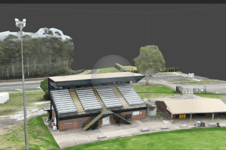
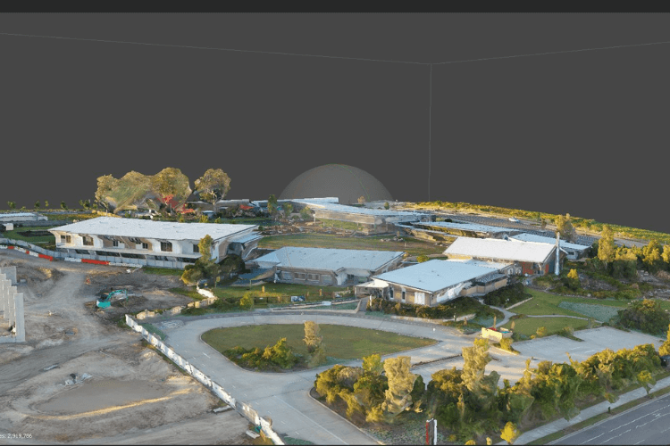
Drone mapping involves equipping UAVs with advanced cameras or LiDAR sensors to capture overlapping images of a construction site from above. These images are processed using photogrammetry software to produce detailed outputs like orthomosaic maps (geometrically corrected aerial images), 3D models, and digital elevation models. This technology provides a bird’s-eye view of your project, delivering data that’s both visually rich and highly accurate.
In Sydney, a city known for its booming construction sector and unique urban challenges, drone mapping is high in demand for commercial drone market. With high-rise developments, sprawling infrastructure projects, and tight timelines, construction firms face pressures to optimize resources while adhering to strict safety and environmental regulations. Drone mapping addresses these needs by offering:
Efficiency: Faster data collection compared to traditional surveying methods.
Safety: Access to hazardous or hard-to-reach areas without putting workers at risk.
Cost Savings: Reduced reliance on manual labor and heavy equipment.
For a Sydney-based business like Upload Enterprise, which specializes in drone mapping and asset inspections, this technology is a key differentiator in delivering value to local clients.
Why Sydney Construction Projects Need Drone Mapping
Sydney’s construction industry is a powerhouse, driven by population growth, infrastructure investments, and urban redevelopment. Projects like the Sydney Metro and Parramatta Light Rail demand precision and speed qualities that drone mapping excels at providing. Moreover, the city’s mix of coastal terrain, dense urban zones, and environmental considerations makes traditional surveying costly and time-consuming. Drone mapping cuts through these challenges, offering a scalable solution tailored to Sydney’s dynamic needs.
Real-World Examples of Drone Mapping in Sydney
Seeing is believing, and Sydney’s construction industry is full of drone mapping success stories. Here are a few local examples:
Measure Australia: Flood Risk Mapping for Shellharbour City Council
Measure Australia used LiDAR-equipped drones to update flood risk maps for Shellharbour City Council, just south of Sydney. This project showcased drones’ ability to handle environmental challenges, delivering precise data in a fraction of the time traditional methods would require. The result? Better planning for flood-prone areas and enhanced community safety.
AAISYD: Precision Mapping for NSW Quarries
AAISYD, a Sydney-based drone service provider, offers survey-grade accuracy for quarries across New South Wales. Their 3D models and point clouds help construction firms calculate stockpile volumes and plan site layouts with pinpoint accuracy—proof of drone mapping’s versatility beyond urban settings.
Stolthaven Terminals: Rapid Marketing Videos
Measure Australia also partnered with Stolthaven Terminals, completing aerial footage for marketing videos in hours rather than days. This efficiency highlights how drones can support not just technical tasks but also project promotion—a bonus for Sydney developers looking to showcase their work.
These cases demonstrate drone mapping’s real impact, from environmental planning to operational efficiency, right here in Sydney.
How Drone Mapping Works: A Step-by-Step Breakdown
Curious about the process? Here’s how drone mapping turns raw aerial data into construction-ready insights:
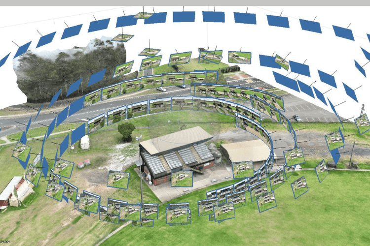
Flight Planning: A drone operator defines the site boundaries and flight path, ensuring full coverage. Weather conditions and CASA regulations (more on this later) are factored in.
Data Capture: The drone flies over the site, taking hundreds or thousands of high-resolution images. LiDAR-equipped drones may also collect laser-based distance measurements for added detail.
Image Processing: Photogrammetry software stitches the images together, correcting for distortions to create orthomosaic maps, 3D models, or elevation profiles.
Analysis and Application: The resulting data is used for site planning, progress tracking, volume calculations, or safety assessments tailored to your project’s needs.
For a Sydney high-rise, this might mean generating a 3D model to check structural alignment, while a suburban development could use an orthomosaic map for boundary verification.
Implementing Drone Mapping for Your Sydney Project
Ready to bring drone mapping to your construction site? Follow this practical guide:
Step 1: Define Your Objectives
What do you need from drone mapping? Common goals include:
Initial site surveys for planning.
Progress monitoring during construction.
Safety inspections of hard-to-reach areas.
Volume calculations for earthworks.
Clear objectives ensure you get the right data for your Sydney project.
Step 2: Choose the Right Outputs
Different projects require different deliverables:
Orthomosaic Maps: Perfect for measuring distances and areas.
3D Models: Ideal for visualizing structures and calculating volumes.
Digital Elevation Models: Useful for topography and drainage planning.
A coastal site in Manly might prioritize elevation models for flood risk, while a CBD tower needs 3D visuals.
Step 3: Select a Trusted Provider
Partner with a Sydney-based drone mapping expert like Upload Enterprise. Look for:
Experience: Proven success in construction projects.
Certifications: Compliance with CASA’s commercial drone regulations.
Equipment: High-quality drones and sensors for accurate data.
Local expertise matters—Sydney’s urban density and weather patterns demand providers who know the terrain.
Step 4: Plan and Execute Flights
Schedule flights during clear weather, avoiding wind or rain that could skew results. Ensure the site is safe for drone operations, adhering to CASA’s 30-meter no-fly zone around people.
Step 5: Process and Use the Data
Once collected, data is processed into usable formats. Integrate it into your workflows—whether feeding 3D models into design software or using maps for stakeholder presentations.
Regulatory Considerations in Australia
Drone mapping in Sydney operates under the Civil Aviation Safety Authority (CASA) rules. Key regulations include:
Height Limit: Drones must stay below 400 feet (120 meters) unless exempted.
Distance from People: Maintain a 30-meter (98-foot) buffer from individuals.
No-Fly Zones: Avoid populated areas or emergency sites without permission.
Commercial operators like Upload Enterprise are fully licensed, ensuring compliance so you can focus on your project, not red tape.
Challenges and Solutions
Drone mapping isn’t without hurdles, but they’re manageable:
Challenge 1: Weather Constraints
Rain or strong winds can ground drones. Solution: Schedule flights during favorable conditions and build flexibility into your timeline.
Challenge 2: Privacy Concerns
Drones flying over urban Sydney might capture sensitive areas. Solution: Secure permissions from property owners and follow data protection laws.
Challenge 3: Data Accuracy
Poor equipment or processing can lead to errors. Solution: Use top-tier drones and software, backed by a provider with a track record of precision.
Why Choose Upload Enterprise for Drone Mapping Services?
At Upload Enterprise, we pride ourselves on delivering reliable and professional drone mapping solutions that empower businesses across Sydney. Here’s what sets us apart:
1. Advanced Technology
We use state-of-the-art drones equipped with high-resolution cameras and LiDAR sensors to ensure unparalleled accuracy.
2. Expertise Across Industries
Our team has extensive experience working with clients in construction, real estate, utilities, agriculture, and more.
3. Customized Solutions
We understand that every business is unique. That’s why we tailor our services to meet your specific needs—whether it’s creating detailed topographic maps or conducting asset inspections.
4. Local Knowledge
As a Sydney-based company, we have an in-depth understanding of the local landscape and regulations governing drone operations in Australia.
Case Study: Drone Mapping Success Story in Sydney
Client: A leading construction firm in Sydney
Challenge: The client needed accurate topographic data for a large-scale residential development project but faced tight deadlines and budget constraints.
Solution: Upload Enterprise deployed drones to survey the site within two days—delivering high-resolution 3D models that enable precise planning and design adjustments.
Outcome: The client saved 30% on surveying costs while completing the project ahead of schedule.
Frequently Asked Questions About Drone Mapping
Q: Is drone mapping legal in Sydney?
Yes! Drone operations in Australia are regulated by CASA (Civil Aviation Safety Authority). At Upload Enterprise, we comply with all regulations to ensure safe and legal operations.
Q: How much does drone mapping cost?
Costs vary depending on factors like the size of the area being surveyed and the complexity of the project. Contact us for a customized quote!
Q: What types of drones do you use?
We use professional-grade drones equipped with advanced sensors like LiDAR and thermal imaging cameras for specialized projects.
Get Started With Upload Enterprise Today
Whether you’re managing a construction project or need detailed asset inspections, Upload Enterprise has you covered with our professional drone mapping services in Sydney. Let us help you save time, reduce costs, and make better decisions with cutting-edge technology.