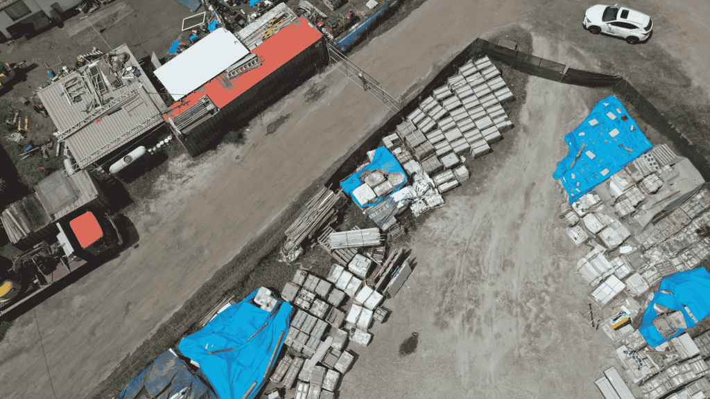
The Junkyard 3D Inspection project aims to utilize aerial 3D mapping technology to efficiently inspect and monitor junkyard facilities. Traditional inspection methods often involve manual checks, which can be time-consuming and pose safety risks. By employing drones equipped with advanced 3D mapping tools, this project seeks to provide a cost-effective and time-efficient solution for maintaining and upgrading junkyard infrastructure.
Background
Junkyards are complex environments with diverse structures and materials, making them challenging to inspect manually. Accurate and detailed inspections are crucial for ensuring safety, optimizing operations, and reducing environmental impacts. Aerial 3D mapping offers a promising approach by capturing comprehensive data without disrupting operations.
Objectives
- Efficient Data Collection: Utilize drones to collect high-quality images and data for creating detailed 3D models of the junkyard.
- Enhanced Safety: Reduce the need for personnel to access hazardous areas to minimize risks associated with traditional inspection methods.
- Cost Reduction: Decrease costs related to equipment rental and personnel safety measures.
- Improved Accuracy: Achieve precise measurements and detailed visualizations to support maintenance and upgrade decisions.
Methodology
- Drone Selection and Equipment:
- Drone Model: DJI Matrice 300 RTK or similar models equipped with high-resolution cameras.
- Software: Utilize photogrammetry software like PIX4D or DJI Terra for 3D model creation.
- Flight Planning:
- Conduct flights in multiple stages to ensure comprehensive coverage of the junkyard.
- Use automatic mission planning tools for efficient data collection.
- Data Collection:
- Capture high-resolution images from various angles and altitudes.
- Ensure sufficient overlap between images for accurate 3D reconstruction.
- 3D Model Creation:
- Process collected images using photogrammetry software to generate detailed 3D models.
- Integrate ground control points for enhanced accuracy.
- Analysis and Reporting:
- Analyze the 3D models to identify areas requiring maintenance or upgrade.
- Provide detailed reports and visualizations to support decision-making.
Challenges and Solutions
- Challenge: Uneven lighting conditions and complex structures can hinder image quality and 3D model accuracy.
- Solution: Use video footage to extract images in challenging conditions and employ lamps or additional lighting devices to improve image quality.
- Challenge: Narrow spaces and lack of GPS coverage can complicate drone navigation.
- Solution: Implement manual flight control in tight spaces and use support points for better orientation.
Results and Benefits
- Comprehensive Coverage: Achieved detailed 3D models of the junkyard, enabling thorough inspections without physical access.
- Enhanced Safety: Reduced the need for personnel to enter hazardous areas, minimizing risks.
- Cost Savings: Decreased costs associated with traditional inspection methods, such as equipment rental and safety measures.
- Improved Accuracy: Provided precise measurements and visualizations to support informed maintenance and upgrade decisions.
Conclusion
The Junkyard 3D Inspection project demonstrates the effectiveness of aerial 3D mapping technology in enhancing inspection efficiency, safety, and accuracy. By leveraging drones and advanced software, this approach offers a valuable tool for maintaining and optimizing junkyard operations while reducing costs and risks associated with traditional methods.

bgwyuv
77eylm
in16kn
ch4m4t
ichqe7
ezx7ol
k1ga77
211ti7
oxm9ts
jgz20i
zdtiw4
v061qt
uqxet0
4xly2a
ytqg2i